DRAINAGE IN INDIA
Drainage in India is the unique chapter that covers the detail summary of class 9 which describes the rivers and water sources in India
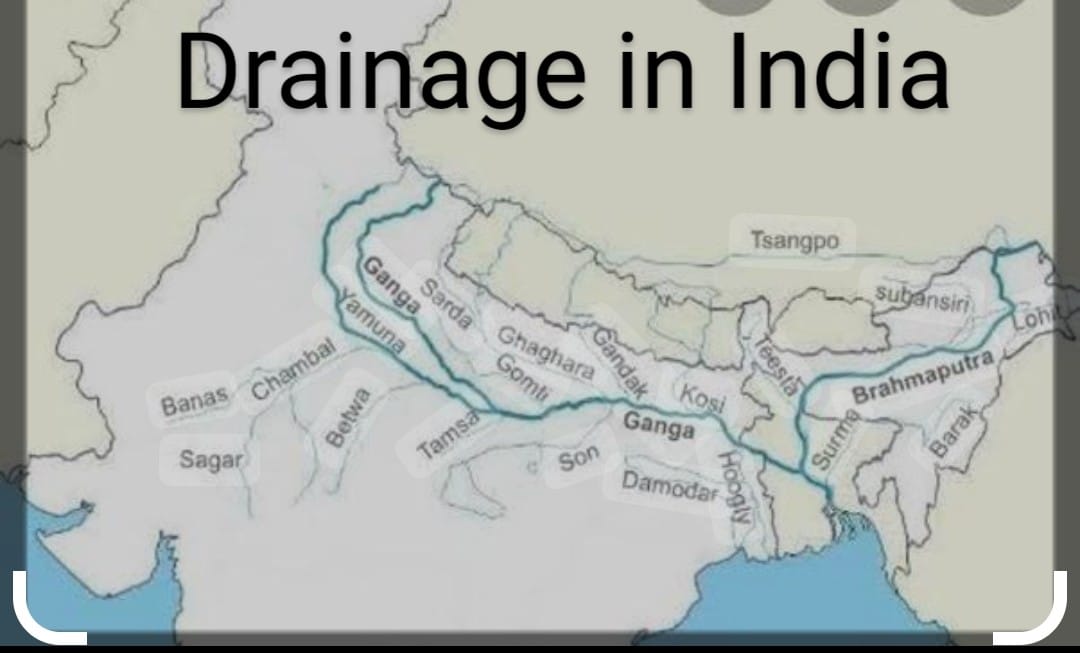
DRAINAGE is the term that describes the river system of the particular aera. The area drained by the rivers system is called a drainage basin
.The world largest drainage basin is the Amazon River and The Ganga is the largest drainagr basin in India .
Any elevated aera like mountain or the upland which separate the two drainage Rivers are divided in two major groups
a) The Drainage of the Himalayan rivers such as the Indus river system, the Ganga river system , the Brahmaputra river system
b) The Drainage of the Peninsular rivers such as the Narmada basin , the Tapi basin , the Godavari basin , the Mahanadi basin , the Krushna basin and the Kaveri basin
Some Features made by rivers are source of river, the upper course, the middle course , the meander, ox-bow lake , the lower course , delta and the mouth .
The river which is filled with water through out yea is called the Perennial Rivers .The river along with it’s tributaries is called the river system .The smaller river which joins a large rivers is called the tributary of the large river.
The Himalayan Rivers : In the upper course the speed of water is very high therefore it cuts the valley to make waterfall , V shaped valley , rapid gorges and the canyon and crescent with them
In the middle course the vertical erosion gives way to side erosion and therefore forms alluvial fans, alluvial plains and meanders
In the lower course the rivers loses it’s carrying capacity due to absence of slope and hence deposit all it’s silt and debris to form flood plain , braided channels , ox bow lakes and delta etc.
According to the Indus Water Treaty in 1960 India can use only 20% water of the Indus river system .
The main difference between the Himalayan rivers and The Peninsular rivers
a) The Himalayan rivers are perennial as they are fed by the melting of snow ,They have long course ,flown through unstable aeras of new fold mountains of Himalayas. They perform high erosion and depositional work in their course.
b) Peninsular rivers are seasonal as fed by rain water ,have short course which are mostly flown through stable aeras of Gondwana land .They don’t perform these activities on such scale.
Interesting Facts : i) The head of the Ganga is called Bhagirathi , is joined by the Alaknanda river at Deva Prayag in Uttarakhand.
ii) At Haridwar the Ganga emerges from the mountain on the plain
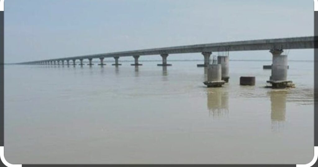
iii) The Brahmaputra river is known as Tsang Po in Tibet and The Jamuna in the Bangladesh .It enters India in Arunachal Pradesh Where it is called Dihang
iv) The Sunderban Delta is the world largest and fastest growing delta
v) Narmada river originates from Amarkantak Hills in MP and forms the water fall Dhuadhar Waterfall near Jabalpur( MP)
vi ) River Kaveri makes the second biggest waterfall in India called Shivsamudram
vii ) The India’s biggest waterfall is Jog waterfall on Sharavati river in Karnataka
viii) The Namami Gange Programme is the integrated conservation mission approved in June 2014 to accomplish the two objective the abatement of pollution conservation and rejuvenation of the national river the Ganga
Lakes are not only a place of scenic beauty but also have socio economic importance like it encourage tourism, it also help in generating hydro electricity , regulates the flow of river water,
During the excessive rainfall it control the flood whereas during draught it ensures the supply of water ,It also helps in balacing the aquatic ecosystem .
They are also the source of salt manufacturing site example Wular lake in Bandipore (J&K), Sambhar lake the largest salt lake in Sambhar lake town in Jaipur Rajasthan
, Chilika Lake largest brackish lake spread over Puri, Khordha and Ganjan districts of Odisha on the east coast of India and Pulicat lake in Andhra Pradesh between the Arani river at south and Kalangi river in the northwest Tamil Nadu .
Important Information of Rivers of India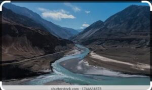
INDUS : i) origin point Mansarovar Lake in Tibet
ii) Length 2880 km ,;708 km lies in India
iii) Tributaries are The Sutlej, Beas, Chenab, Ravi and Jhelum
iv) Itis one of the longest river in the world,originates from Mansarovar lake in Tibet ,it flows westward to enter India in Ladhak , It drains into the Arabian sea
v) It drains the aera in J&K , Himachal Pradesh and Punjab( Pakistan )
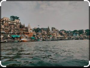
The Ganga : The origin point is Gangotri Glacier ( Himalaya) length is 2500 km it’s main tributaries river the Yamuna, Ghaghara, Gandak , Kosi , Chambal , Betwa , Son it drains Uttarakhand, UP ,Ambala
The Ganga river separates from The Indus river net work and surrounded by two rivers The Ghaggar and Tangri The average slope is one meter per 6 km ,It is the one of the most sacred and the longest flowing the river of India
The head water of Ganga is called Bhagirathi is joined by Alaknanda at Deva Prayag. the Ganga at Haridwar comes to plains .
It drains in the Bay Bengal before which it forms the world’s largest delta Sundarban with Brahmaputra river. The main stream of Ganga and Brahmaputra river Meghna in Bangladesh .
THE BRAHMAPUTRA It originates from The Manasarovar lake Tibet , it’s length is 2900km main tributaries are Dabangg , Lohit , it drains to Tibet , Arunachal Pradesh , Assam, Bangladesh . It is slightly longer than Indus river, most of the course flows in Tibet outside India parallel to Himalaya on reaching Namcha Barwa it takes U turn and enters India and Tibet is the cold dry region .
NARMADA originates from Amarkantak hills of MP which is 1312 km with Sakkra , Dudhi, Tawa and Ganjal as tributaries drains MP and some part of Gujarat. It flows towards the west in a rift valley formed due to faulting and forming gorge in marble hills and Dhuandhar waterfall
TAPI originates from Satpura ranges in MP about 725km ,Purana, Grina the Vaki ,the Gomai and Panjhra that drains MP and Gujarat and Maharashtra it flows parallel to Narmada through rift valley.
GODAVARI originates from the slopes of western ghats in Maharashtra which is1500km long drains Maharashtra , MP, Odisha , Andhra Pradesh and Telangana it is the longest river of south India having tributaries as the Pravara , the Purna , the Manjra , The Wardha, the Indravati
MAHAHANADI originates from the highland of Chhattisgarh about 800km drains Maharashtra, Odisha , Chhattisgarh and Jharkhand drains into The Bay of Bengal having tributaries Seonath , Jonk , Hasdeo ,Ib ,Ong
KRISHNA originates from Mahabaleshwar of Maharashtra also drains it along with Karnataka and Andhra Pradesh drains into the Bay of Bengal .with the main tributaries the Ghataprabha, the Malaprabha , the Bhima
CAVERY originates from Tala Kaveri hills of western ghats having the length of 760 km drains Tamil Nadu , Kerala and Karnataka and also drains into Bay of Bengal and tributaries are Arkavathy, Shimsha , Hemavati , Kapila Amaravati
Difference between tributaries and distributaries :
Tributaries are the small river which joins a large river that increases the water level of main river example the Yamuna, the Kosi are the tributaries of the Ganga whereas Distributaries are formed in the lower course of the river water is divided into many channels which reduces the level of water example Bhagirathi and Hooghly is the distributaries of the Ganga
Conclusion : Drainage of India
Drainage in India is the greatest gift of nature to us which is used for multi-purposes projects such as irrigation, hydropower, navigation etc .Drainage in India is a very important aspect of the country’s geography, shaping its landscape and influencing human activities. India has two major drainage systems which are the Himalayan and the Peninsular. Rivers play a vital role in agriculture, transportation, and power generation. The country faces challenges like floods, droughts, and water pollution. Proper management of water resources is needed for sustainable development of the drainage system of India. Conservation efforts and awareness are needed to protect India’s river systems.
Read More : Climate
Read More : India Size location and Physical Features
Follow us on : Facebook